“Tropical storm conditions are expected within the warning area along the northeastern coast of South Carolina this morning and will spread northeastward within the warning area along the North Carolina coast this afternoon into Sunday,” the Hurricane Center wrote, also cautioning that pockets of heavy rain could also cause areas of flash flooding in this zone.
The system was hardly on the Hurricane Center’s radar as recently as Friday morning. The Hurricane Center’s first public bulletin about the system came at 2 p.m. Eastern time Friday: “Low pressure has formed near Savannah, Georgia. Although significant development of this system is not likely, heavy rains are expected across southeastern Georgia and portions of the Carolinas.”
In its 5 a.m. discussion Saturday, the Hurricane Center wrote that the storm had developed “rather unexpectedly” as thunderstorm activity embedded within the disturbance organized late Friday into early Saturday.
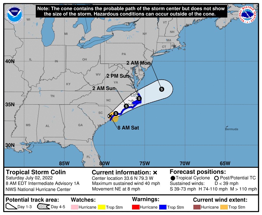
As of 8 a.m. Saturday, Colin was centered about 25 miles west-southwest of Myrtle Beach. It was a minimal tropical storm, with maximum sustained winds of 40 mph and heading northeast at 8 mph. Over the next day, it is forecast to continue northeastward, paralleling the coast of the Carolinas, before eventually pulling away more to the east.
Colin is not projected to strengthen but will be a nuisance for residents and visitors along the coast of the Carolinas. In addition to gusty winds up 40 mph or so, Colin could produce 1 to 2 inches of rain, with isolated heavier amounts up to 4 inches.
The National Weather Service also issued a hazard statement for “dangerous rip currents” along the North Carolina coast.
Good morning E NC! Overnight Tropical Storm Colin spun up along the SC coast. Colin is forecast to move NE @ 8 mph taking the storm along or just inland of the NC coast today & Sun. The main impacts will be locally heavy rains, coastal wind gusts to 40 mph, & possibly a tornado. pic.twitter.com/YWzoQeyGMn
— NWS Newport/Morehead (@NWSMoreheadCity) July 2, 2022
Between Friday and Saturday morning, the system had produced 2 to 4 inches of rain around Charleston, where the showers had mostly moved off to the north and east.
Computer model simulations indicate that most of the rain from Colin will remain east of its center, over the ocean, but that intermittent, scattered downpours are a good bet in northeastern South Carolina and southeastern North Carolina on Saturday into Saturday night and along the North Carolina Outer Banks through around midday Sunday.
By Sunday night, Colin is expected to be well east of the Mid-Atlantic coast and dissipating.
As the third named storm of the Atlantic season, Colin formed about a month ahead of schedule; the average date of the third named Atlantic storm is Aug. 3. The National Oceanic and Atmospheric Administration is predicting a substantially busier-than-average hurricane season, with 14 to 21 named storms, including six to 10 hurricanes and three to six major (Category 3 or higher) hurricanes. The Atlantic season typically peaks in late August and September.
While Colin scrapes the coastal Carolinas, Tropical Storm Bonnie is about to exit Nicaragua and enter the Pacific Ocean. Bonnie made landfall near the Nicaragua-Costa Rica border around 11 p.m. Eastern time Friday, with winds of 50 mph. While passing through the two countries, it is likely to produce 4 to 8 inches of rain and “life-threatening flash flooding and mudslides,” the Hurricane Center predicted.
Bonnie is forecast to become a hurricane over the Pacific Ocean but avoid land.